
In an era defined by rapid technological advancement and an insatiable desire for creative expression, applications that empower users to reimagine fundamental aspects of our world truly stand out. Among these innovative tools is “World Provinces, Empire, Maps,” an intriguing Android application developed by Cygnus Software. Far more than a mere mapping utility, this app transforms your mobile device into a powerful digital canvas, inviting you to become a cartographer, a historian, and a geopolitical architect all at once. It’s a platform designed for those who have ever looked at a world map and thought, “What if…?” or dreamed of shaping civilizations from the ground up.
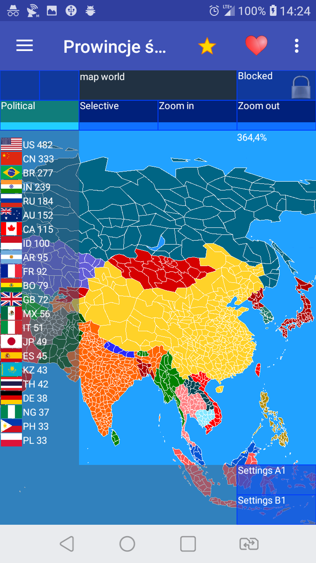
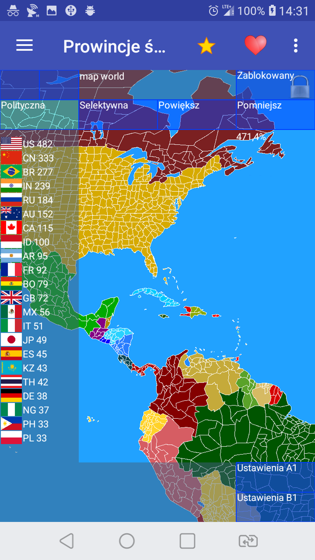
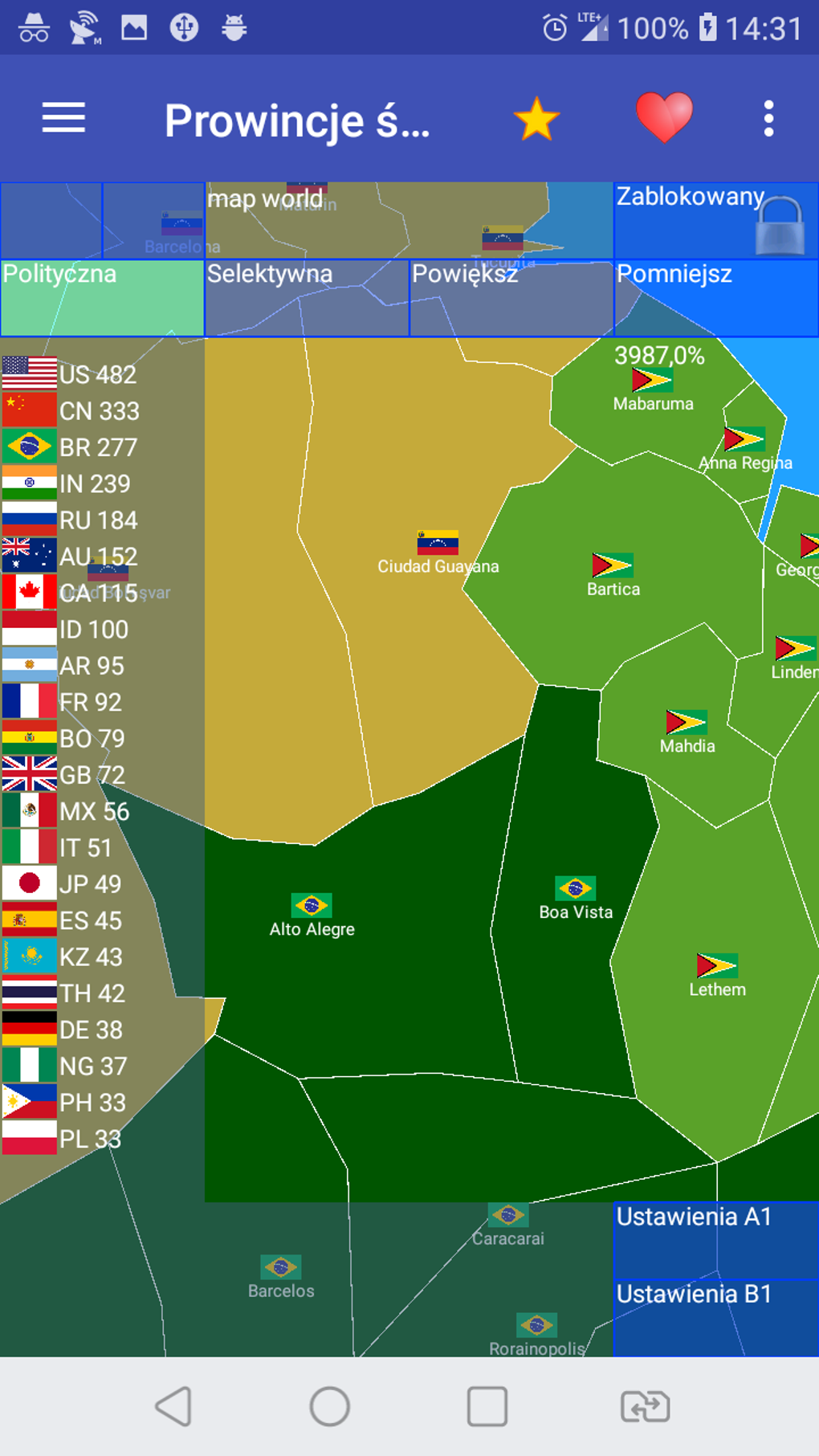
At its core, “World Provinces, Empire, Maps” offers an unparalleled level of customization and creative freedom. It enables users to design their own world map entirely from scratch, a feat that would once require extensive geographical knowledge, artistic skill, and specialized software. The depth of this customization is truly remarkable, featuring over 4,000 individual provinces that can be manipulated, assigned, and organized according to your vision. This granular control allows for the creation of intricate political boundaries, detailed administrative divisions, and a truly unique global tapestry. You are not just drawing lines on a pre-existing map; you are crafting the very fabric of an imagined or re-imagined world.
Beyond the blank slate, the application provides a robust framework for bringing your creations to life. Users can freely choose which countries to include in their new world, deciding the fate and influence of nations, both familiar and entirely novel. With hundreds of built-in countries and their corresponding flags, the possibilities are virtually limitless. Imagine a world where the Roman Empire never fell, or where ancient Egypt expanded across continents, or perhaps an entirely new superpower emerges from the ashes of old nations. The app supports this vision, allowing for the meticulous construction of national identities, complete with names, borders, and even a written history that you, the user, can pen. This rich feature set ensures that every map created is not just a visual representation, but a narrative waiting to unfold. From the United States to China, Russia to Germany, France, Italy, Japan, Canada, Australia, Mexico, Argentina, Egypt, Greece, and many more, the existing nations provide a solid foundation, while the tools for innovation beckon imaginative minds to transcend current realities.
The Power of Creation: Unleashing Your Inner Cartographer and World-Builder
“World Provinces, Empire, Maps” empowers users to step into the shoes of a cartographer and a world-builder, offering a robust suite of tools that transcend the capabilities of typical map applications. This isn’t merely about viewing existing maps; it’s about actively participating in their construction and deconstruction. The concept of designing a world map “from scratch” is central to its appeal, promising an experience that is both intellectually stimulating and deeply satisfying for creative individuals.
The fundamental building blocks of any geopolitical map are its provinces. The application provides an astonishing number of these – over 4,000 – allowing for an incredibly detailed and nuanced approach to territorial design. This level of granularity means that users can define borders with precision, creating realistic or fantastical geographical divisions that reflect their specific intent. Whether you’re aiming for historically accurate regional divisions or imagining completely novel administrative zones for a fictional realm, the sheer volume of manageable provinces ensures that your vision can be meticulously executed. This granular control is crucial for anyone serious about world-building, as it allows for the differentiation between major cities, rural hinterlands, and strategic choke points, all of which contribute to the political and economic landscape of your designed world.
Once the provincial layout is established, the next layer of creation involves defining the countries themselves. The application offers unparalleled flexibility in this regard. You can select from a vast library of “hundreds of built-in countries with flags,” providing immediate recognition for familiar nations. However, the true power lies in the ability to “freely choose which countries to include in this new world,” and, critically, to conceive “entirely new ones.” This feature is a goldmine for creators. Want to introduce a breakaway republic in a traditionally unified region? Done. Dream of merging several historical enemies into a single, dominant empire? Possible. The ability to name these new entities and even “design their history” adds a profound narrative dimension to the cartographic exercise. Each nation becomes more than just a color on a map; it gains a backstory, a reason for being, and a potential future within the grand tapestry of your creation. This makes the app an invaluable tool for writers, game developers, and anyone involved in creating immersive fictional universes, as it provides a visual and structural foundation for their narratives.
The user interface, though not explicitly detailed in the description, is implied to be intuitive and interactive given the nature of the task. The phrase “immersive, interactive platform” suggests that manipulating these provinces, assigning countries, and drafting histories is a fluid and engaging process. The visual feedback of seeing your world take shape province by province, country by country, is a powerful motivator. This interactive design is key to translating complex geopolitical ideas into tangible visual forms, making the often-daunting task of world-building accessible and enjoyable for a wide audience. The act of designing, naming, and attributing historical context transforms a simple map into a living, breathing world, limited only by the creator’s imagination.
A Journey Through Time: Recreating Historical Empires and Alternate Realities
One of the most captivating aspects of “World Provinces, Empire, Maps” is its profound ability to serve as a digital time machine, allowing users to not only explore but actively manipulate historical geography. For history enthusiasts, the application transcends passive learning by offering an interactive sandbox where “your passion for history can truly come alive.” This goes beyond simply viewing historical maps; it provides the tools to reconstruct, analyze, and even rewrite historical narratives through geopolitical reconfigurations.
The prompt notes the capacity to “recreate historical empires.” This feature is incredibly powerful for students, educators, and hobbyists alike. Imagine meticulously mapping out the vast expanse of the Roman Empire at its zenith, assigning its numerous provinces, vassal states, and client kingdoms. Or perhaps tracing the nomadic routes and conquered territories of the Mongol Empire, stretching from East Asia to Eastern Europe. The app’s over 4,000 provinces offer the necessary detail to approximate these historical boundaries with a degree of accuracy previously difficult to achieve without specialized GIS software. Users can choose from the built-in countries, selecting Rome, Egypt, Greece, and others, and then expand their borders piece by piece, province by province, to reflect the historical record. This hands-on approach deepens understanding of the geographical and logistical challenges faced by these ancient powers, as well as the sheer scale of their territorial control.
Beyond simple recreation, the application opens the door to exploring “alternate realities” and counterfactual history. This is where the creative and analytical potential truly shines. What if Napoleon had won at Waterloo? How would the world map have shifted if the British Empire had retained all its colonial holdings well into the 21st century? Or what if a different outcome to World War II led to a vastly altered geopolitical landscape? With “World Provinces, Empire, Maps,” users can implement these hypothetical scenarios. They can adjust borders, annex territories, create new successor states, and even merge existing nations to reflect a divergent historical path. This allows for critical thinking about historical turning points and their potential ripple effects on global geography and political power structures. By actively shaping these alternative histories, users gain a deeper appreciation for the contingencies and complexities of real-world historical development.
The ability to “design their history” for any created or modified country further enhances this journey through time. When you create a new nation or dramatically alter the borders of an existing one, you aren’t just changing a visual representation. You are encouraged to invent the narrative that explains these changes. Why did this empire rise? What were its key conquests or diplomatic maneuvers? What internal conflicts led to its fragmentation, or what external pressures forged its alliances? This narrative layer transforms the mapping exercise into a rich storytelling experience, where geopolitics and historical events are intertwined. For role-playing game masters, historical fiction writers, or even speculative fiction authors, this feature provides an indispensable tool for grounding their imaginative worlds in believable (or compellingly unbelievable) historical contexts. It’s an exercise in both geographical precision and narrative invention, demonstrating that maps are never truly static; they are reflections of power, conflict, and the continuous ebb and flow of human history.
Beyond the Borders: Unpacking the Features of World Provinces, Empire, Maps
To truly appreciate the scope and utility of “World Provinces, Empire, Maps,” it’s essential to delve deeper into its specific features and how they coalesce to create such a versatile platform. The application is a testament to thoughtful design, blending extensive data with intuitive controls to cater to both casual enthusiasts and serious world-builders.
At the heart of the app’s detailed functionality is its provincial system. With “over 4,000 provinces,” the level of geographical detail available to the user is exceptionally high. This isn’t just a large number; it signifies the capacity for fine-grained control over landmasses, coastlines, and internal divisions. Each province acts as a discrete unit that can be individually assigned to a country, allowing for the meticulous drawing of borders that might follow natural geographical features like rivers or mountain ranges, or purely arbitrary lines dictated by historical treaties or military conquests. This precision is vital for creating believable maps, whether they represent historical realities or fictional worlds. Without this granular control, maps would appear blocky and unrealistic, lacking the organic flow that comes from intricate border work.
Complementing the provincial system is the extensive library of “built-in countries with flags.” The mention of “hundreds” of these, including major global players like the United States, China, Russia, and European powers, alongside nations from South America, Africa, and Asia, means that users have a readily available palette of established entities. This is beneficial for quick historical recreations or for building a world that partially mirrors our own. Each country comes with its recognizable flag, adding a layer of visual authenticity and immediate identity. However, the true power emerges from the ability to “freely choose which countries to include” and, more importantly, to “conceive entirely new ones.” This means that users are not bound by existing political structures. They can combine small historical states into large empires, split modern nations into warring factions, or invent entirely novel civilizations with unique names and flags. This freedom to define the political entities is a cornerstone of the app’s world-building capabilities.
The narrative layer is another critical feature that elevates “World Provinces, Empire, Maps” beyond a simple drawing tool. The ability to “design your own world map from scratch, including the name, and history” for each entity transforms the mapping process into a storytelling endeavor. A map is rarely just lines and colors; it tells a story of conflict, alliance, migration, and power. By allowing users to write the history of their created countries and worlds, the app encourages a deeper engagement with the geopolitical dynamics they are simulating. This could involve crafting a detailed timeline of a nation’s rise and fall, describing its cultural characteristics, or outlining its political ideologies. This feature makes the application particularly attractive to writers, game designers, and educators who wish to imbue their geographical creations with rich, underlying narratives.
Moreover, the phrase “immersive, interactive platform” hints at an intuitive user interface that facilitates these complex tasks. While specific UI details are not provided in the reference, it can be inferred that the app employs touch-friendly controls, perhaps drag-and-drop functionality for assigning provinces, and simple selection tools for country management. The responsiveness of such a platform would be crucial for a smooth creative workflow, allowing users to experiment with different configurations without cumbersome navigation. This ease of use ensures that the technical aspects don’t overshadow the creative process, making sophisticated world-building accessible to a broader audience. Ultimately, the synthesis of detailed provincial data, a vast library of national entities, robust historical narrative tools, and an engaging interface makes “World Provinces, Empire, Maps” a truly comprehensive and powerful tool for anyone passionate about geography, history, and creative world design.
Educational Impact and Creative Endeavors: More Than Just a Map App
“World Provinces, Empire, Maps” transcends the conventional definition of a mapping application, emerging as a potent tool for both education and creative expression. Its interactive nature and deep customization options open avenues for learning and storytelling that static maps or traditional textbooks simply cannot provide.
From an educational standpoint, the application offers an unparalleled interactive learning experience for geography and history students. Instead of memorizing capital cities or historical borders, students can actively construct them. By “recreating historical empires,” learners gain a hands-on understanding of the vastness of territories like the Roman Empire or the changing boundaries during periods like the Napoleonic Wars. This kinesthetic learning approach can significantly enhance retention and comprehension. For instance, a student tasked with mapping out the British Empire at its peak would not only identify its various colonial possessions but also grapple with the geographical spread and the logistical challenges inherent in governing such a diffuse entity. The 4,000 provinces allow for detailed historical analysis, enabling students to differentiate between directly controlled territories, protectorates, and spheres of influence, leading to a more nuanced understanding of historical geopolitics.
Furthermore, the app provides an excellent platform for exploring “what if” scenarios in history – a form of counterfactual analysis that encourages critical thinking. What if the Treaty of Versailles had been different? How might the borders of Eastern Europe have evolved if certain historical events had unfolded differently? By allowing students to “conceive entirely new ones” or modify existing countries and their histories, they can actively experiment with the consequences of historical decisions, thereby deepening their appreciation for the complexities of historical causality and the fluid nature of political geography. This makes history not just a series of facts to be learned, but a dynamic, malleable narrative influenced by countless factors.
Beyond academia, “World Provinces, Empire, Maps” is a goldmine for creative endeavors, particularly in the realms of writing, gaming, and speculative fiction. For authors embarking on epic fantasy novels or historical fiction, the app serves as an invaluable world-building utility. They can “design their own world map from scratch,” creating intricate geopolitical landscapes for their stories. The ability to name regions, establish nations with unique flags, and “design their history” provides a robust framework for crafting believable and immersive fictional universes. A writer can visualize the trade routes between their invented kingdoms, understand the strategic importance of mountain passes, or anticipate the impact of a newly formed alliance by seeing it manifest directly on their custom map. This visual aid is crucial for maintaining consistency and depth in complex narrative settings.
Similarly, for game developers, especially those working on strategy games, role-playing games (RPGs), or grand strategy titles, this application can be a powerful prototyping tool. It allows them to quickly sketch out game worlds, establish factions, define territories, and even plan out campaign maps. The 4,000 provinces can represent game-level regions, and the built-in and custom countries can stand in for playable or non-playable factions. The capacity to imbue these with unique histories directly supports the creation of rich lore and compelling in-game narratives. The “immersive, interactive platform” described makes it ideal for iterative design, enabling developers to rapidly test different geographical configurations and their strategic implications before committing to more complex development. In essence, “World Provinces, Empire, Maps” transforms passive learning and conceptual thought into active creation, making it an indispensable resource for anyone looking to understand, teach, or invent worlds.
Getting Started: Navigating the Interface and Community Potential
Embarking on your journey of global redesign with “World Provinces, Empire, Maps” is designed to be an accessible and engaging experience, even for those new to digital cartography. As an Android application, its availability and installation are straightforward, primarily through established app distribution channels. The description highlights its status as a “free app for Android, by Cygnus Software,” indicating a barrier-free entry point for interested users.
The process of getting started likely involves a user-friendly interface that guides you through the initial steps. Upon launching the application, you would probably be presented with an option to start a “new world map from scratch” or perhaps load a pre-existing template or save file. The emphasis on designing “from scratch” suggests a blank canvas approach, where users begin with an undifferentiated landmass (or perhaps even an empty ocean, waiting for continents to be shaped). The core interaction would revolve around selecting and manipulating the “over 4,000 provinces.” This could involve a touch-based system where users tap or draw over provinces to assign them to a newly created or selected country. Color-coding would likely be employed to visually differentiate nations, providing immediate feedback on border demarcation.
Once provinces are assigned, the next logical step would be country management. The interface would offer tools to name your burgeoning nations, either drawing from the “hundreds of built-in countries with flags” or inputting entirely novel names. The selection of flags from the provided library or the potential (though not explicitly stated) to import custom flag designs would further personalize each entity. A crucial part of the process would be the “design [of] history.” This feature would likely manifest as a text editor linked to each country, allowing users to write narrative snippets, timelines, or key historical events that define that nation’s existence within your custom world. This historical narrative is integral to giving depth and meaning to the geographical creations, transforming them from simple colored regions into entities with a story.
While the provided content doesn’t explicitly mention community features, the nature of such a creative and detailed application inherently suggests a strong “community potential.” Users who invest time in designing intricate worlds and compelling histories would undoubtedly want to share their creations. Imagine forums or in-app galleries where users could upload their custom maps, complete with the names and histories of their empires. This could foster a vibrant community of cartographers, historians, and world-builders who exchange ideas, offer feedback, and inspire new creations. Such a platform could even lead to collaborative projects, where multiple users contribute to a shared world, each designing their own region or historical era. The ability to export and import maps (perhaps as specific file formats) would be essential for this sharing, allowing others to explore and build upon existing designs. This could elevate the app from a personal creative tool to a collaborative and educational platform, further extending its reach and utility.
Availability and Technical Details
As per the information, “World Provinces, Empire, Maps” is available as a “free app for Android,” making it accessible to a wide audience. The current version is listed as “V1.35.1,” with a recent update on “July 28, 2025,” suggesting active development and ongoing improvements by Cygnus Software. The app supports “Android 13.0” and is primarily available in “English,” with additional language support including German, Russian, Polish, Italian, French, Spanish, Portuguese, and Arabic, indicating a global reach and commitment to diverse users. With “5.1K” downloads and “251” last month’s downloads, it demonstrates a steady interest from the Android community. PhanMemFree has reviewed it positively, granting it a “4.8/5” rating and certifying it as a “Trusted Program,” which provides a strong endorsement for potential users. Its status as an “Education & Reference” app on PhanMemFree.org further solidifies its position as a valuable tool for learning and creative exploration.
In conclusion, “World Provinces, Empire, Maps” by Cygnus Software is a powerful, flexible, and utterly engaging application for anyone with an interest in geography, history, or creative world-building. Its comprehensive feature set, including thousands of customizable provinces, hundreds of built-in countries and flags, and the ability to craft unique histories, provides an unparalleled sandbox for geopolitical exploration. Whether you’re an aspiring historian seeking to reconstruct ancient empires, a writer designing a fantastical realm, or simply a curious mind eager to reshape the world, this app offers the tools and the freedom to bring your grandest visions to life directly on your Android device. It’s more than an app; it’s a portal to countless alternate realities, waiting for you to chart their course.
File Information
- License: “Free”
- Latest update: “July 28, 2025”
- Platform: “Android”
- OS: “Android 13.0”
- Language: “English”
- Downloads: “5K”
- Download Options: “Google Play”


